Kansas City Builds an Economy
(KC 1900 Series: # 2)
Here where these rocky bluffs meet and turn aside the sweeping current of this mighty river; here where the Missouri, after pursuing her southern course for nearly two thousand miles, turns eastward to meet the Mississippi, a great manufacturing and commercial community will congregate and less than a generation will see a great city.
Senator Thomas Hart Benton – 1852 speech in Kansas City
Kansas City’s rose up from its geographic influences – from is geology and topography, to its anthropology and economics. The subject of the history of the Convention Hall begins there as well. Were it not for its geography, the Convention Hall might have been built in another location entirely, forever affecting the city form built after it. More importantly, geography was at the center of what made Kansas City grow, and made it worthy of and ideally suited for a Convention Hall.
There is much Kansas City history to tell from its earliest beginnings to the late 19th century, and many fine sources of that history. But thankfully for us all, I’m content with providing a general reminder of three periods in the city’s history that help explain the connection between those early years and the ultimate manifestation of a Convention Hall.
Early 1800s:
There had been native peoples here forever. Even when Lewis and Clark floated by in 1804, there were already men who had explored the west for their personal interests in trade or trapping. The mission of the Corps of Discovery was greater. Lewis and Clark came to map the west for the government’s interests in the future. Many settlements along the Missouri River were established because of the travels of the Corps, but Kansas City was in the perfect position to capitalize on the “opening of the west” before the others. The spot that would become Kansas City was the first major place for trade, with its confluence of the Kansas and Missouri rivers. Having established a foothold, the founders of Kansas City started making the local economy a place that took the greatest advantage of its location. Kansas City became what St. Louis has claimed – the gateway of the west. If St. Louis was a gateway, it was a gate to a single path west, the Missouri River. Kansas City was the gate that swung wide, and opened the northwest, southwest and far west to the agents of change. The gate swung wide to the east, too, happy to help bring the wealth of the new world to the old.

1830 to 1860s:
The era of the Overland Trails further fueled the area’s growth, and turned Kansas City into the ultimate “jumping off place.” The Santa Fe Trail opened up, and a vital trade route that now connected the United States and Mexico ran right through Independence, then Westport. Gold was discovered in California, and almost every overland route to the gold fields came through Westport, where prospectors spent their last cent with certainty of its ability to grow into a fortune. The territories of the northwest that became Oregon and Washington were opened to settlement, and families came through in the thousands, again, loading up in Kansas City. All told, about a half million people traveled through this area on their way west in the twenty years before the Civil War.
Every event that had contributed to the growth of Kansas City and helped insure the city’s place as a center of enterprise gave the community every reason to believe it could continue to grow well into the future. Except for one thing. There was no more room to grow. The city had become so crowded with its success that it was crammed between the south bank of the Missouri River and the foot of the limestone bluffs just a few hundred south. There was only one way to go – up. Up to the top of the bluffs.

The ravines that runoff had carved in the bluffs over millions of years were only a start. What were needed were ravines thirty, forty, fifty feet deep, in some places more. The city began the arduous, almost impossible job of claiming the high ground of the bluffs by clawing up and then through them. They started slowly at first, in the 1850s, then delayed during the Civil War, revived after the war, continued through the end the 19th century. Kansas City’s new nickname became Gullytown.
The city first budgeted $10,000 for improvements, to dig below grade to create Main Street. The edge of the bluff near the river was graded down, and the levee widened and paved for the distance of one quarter of a mile. Within the next three years, Second, Third, Fourth and Fifth Streets were improved; Broadway and Wyandotte, Delaware, Main and Market (Grand Avenue) Streets were graded from the river south to Fifth Street.
To provide a more contemporary account of this effort, I have included some excerpts from the narrative of this period found in Carrie Westlake Whitney’s Kansas City: Its History and Its People, Vol. I, 1908 (a separate KCB story on Whitney can be found here.) Whitney’s account provides more detail on the grading project than any account I’ve seen to date. And while some modern-day citizens might bemoan the loss of these natural outcroppings, it’s interesting to note what Whitney notices from the viewpoint of the day:
Obstacles in the shape of elevations or depressions were met at every turn, tons and tons of rock have been torn from the crest of the hills and used to fill up the valleys and ravines, and out of the chaos a beautiful city with magnificent thoroughfares, has arisen. The cliffs and valleys that were left undisturbed later were utilized to beautify the driveways and boulevards… In looking backward through the years to the dim horizon of fifty years ago, one can scarcely realize the wonderful transformation that has taken place, topographically, in Kansas City. It required wonderful perseverance and energy to make Kansas City sightly.
1870-1890:
This final era of Kansas City’s pre Convention Hall period began around 1870, even though the construction of the hall wouldn’t get truly underway for about twenty years. To begin, in 1870, the Hannibal Bridge was built by the Hannibal & St. Joseph Railroad Company, and for the first time, a rail line crossed the Missouri River. For several years any commodity needing to cross that divide traveling in either direction had to make its way through Kansas City to do so. And because of that, Kansas City became an early home to the railroad industry as it conquered the west. And then it built a stockyard, second only to Chicago’s, which in turn justified building a new Union Depot in the West Bottoms. From which the growing independent interurban lines began to form a network that helped to define Main Street as just that – a larger version of an “everytown” main street.
So began Kansas City’s life as a true crossroads, a place that connected the corners of America – the cultured east with the western wilderness, the industrial northeast with the agricultural southwest. Whether by river or trail, or rail, Kansas City was a physical crossroads. Whether to trade, to make, to buy or to sell, Kansas City was an economic crossroads. And those fortuitous intersections brought investment interests from the financial capitals of the eastern seaboard.
Of course, Kansas City was infamously known as a rowdy, open town. That rough side was part of the attraction for some, but for most, it made them cautious. The city struggled with that image for years, and in the early 1890s, the city was at a turning point. But turning from what to what? In Kansas City’s case, it’s from the type of city it had become while no one was much paying attention, to the city it imagined itself to be, or could be, and for some people already heavily invested in Kansas City’s future, the city it simply had to be. A producer of wealth and influence.
And so the civic discourse began on how to remedy the situation and redraw the city’s image in the eyes of the country. It didn’t take long for the convention hall idea to rise to the top of the list, where it found the influential champions it needed, those who recognized the opportunity for all its virtues. The city had a well invested and successful old guard, fresh eastern money, political leverage, and the economic foundation of the railroads and the stockyards. What they wanted and needed was a combination civic monument, world-class spectacle, and most importantly, an icon of Kansas City’s economic success and its vision for the future.
And what better to fit that bill than a public building, a building that could house the spectacle of a circus, grand concerts by the likes of John Philip Sousa, industrial expositions highlighting the city’s economy, or conventions bringing industry leaders or political candidates and their entourages of power brokers? Nothing, that’s what. Nothing could be better.
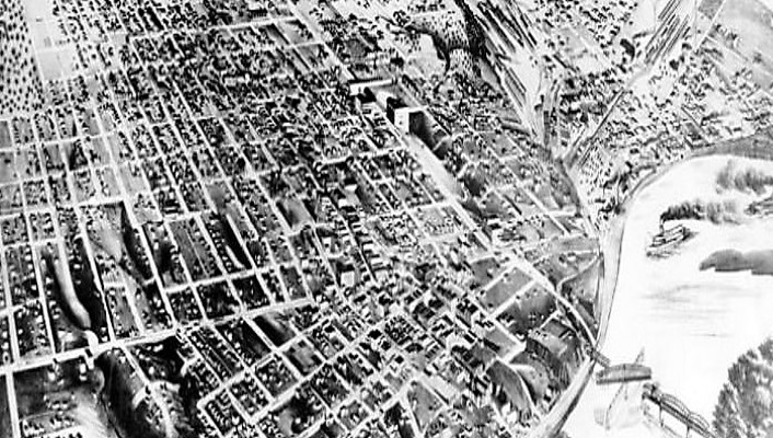
Banner Photo: Bird’s Eye View map of Kansas City, circa 1870
