(originally published 5/21/20)
It doesn’t seem possible that 1920 is one hundred years ago. My parents were born within a few years of either side of that date, and so growing up, when I remember them best in the 1960s and 70s, 1920 was only about 40 or 50 years earlier. Now, I hate to recall, those 60s and 70s were 50 or 60 years ago. Time doesn’t just fly. It speeds through like a Land Speed Record car – the thrill is in the anticipation as it comes hurtling toward you, but it disappears into the distance at an alarmingly fast rate in a blur.
I’ve gone back to the archives of my two favorite local history resources, the Kansas City Public Library and the State Historical Society of Missouri, to cherry pick some photos from 1920 that remind us (or at least me) how long ago 1920 was, and how much the city has changed since then. Each picture was chosen because of that very fact – it’s a symbol of change, a reminder that change is constant, and not just there when thrust upon us.
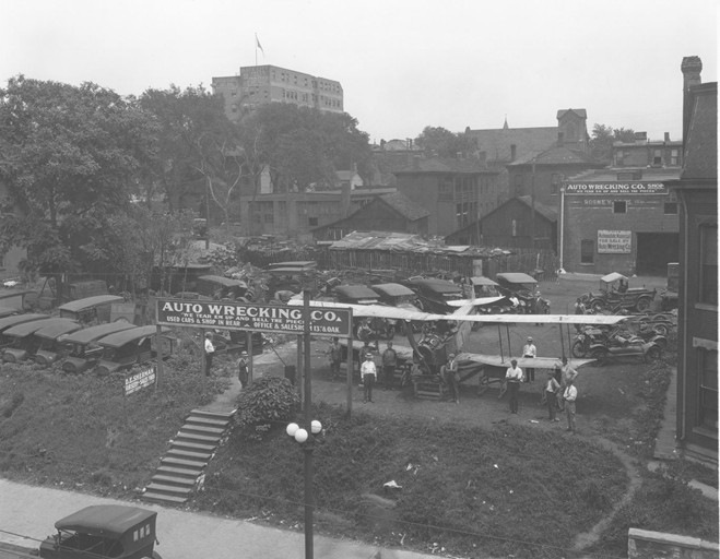
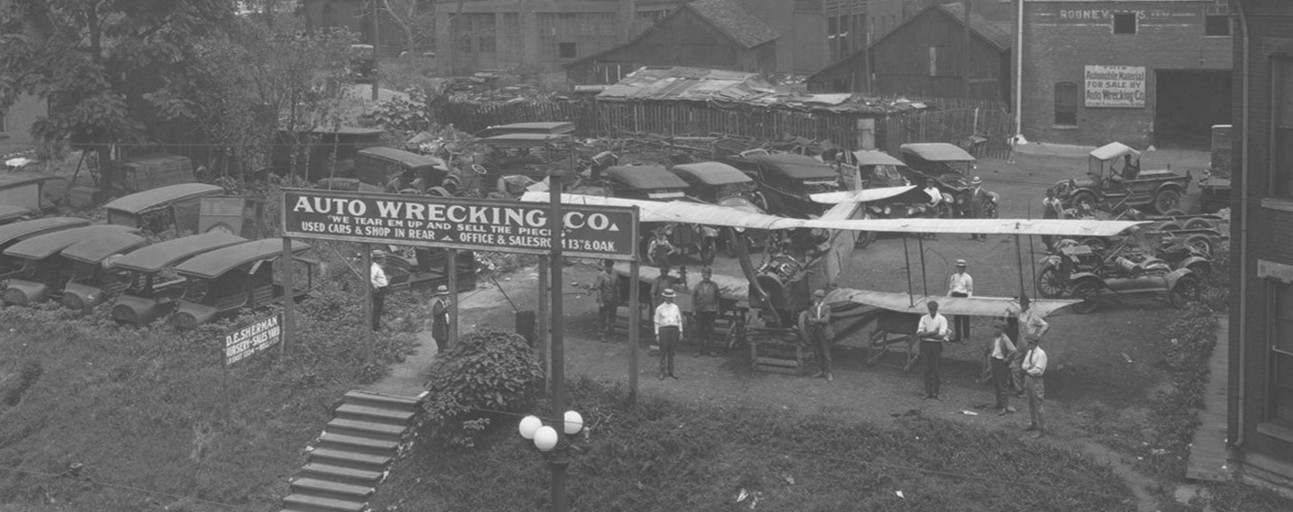
Let’s begin with the feature photo (top). While the photo doesn’t have a specific address associated with it, based on geography, some address clues hidden in the photo, and a familiarity with how this city has developed, I believe this photo was taken somewhere in the vicinity of what today we think of the East Crossroads, the flats just north of Hospital Hill. There have been “junk yards” there since at least 1908, and some are there still. In that respect, it hasn’t changed. What has changed is that now, the treasures, like the airplane shown here, are hidden from view by virtue of city ordinances that protect us from what we believe to be a visual assault. In 1920, this yard was in full view of the public. The variety and value of its offerings were in bold display. The stairs leading up to the large sign were the business’s front door. And the workers there mostly seem to be dressed in slacks, white shirts and straw boaters. A business of which to be proud. (This image is a detail of an uncropped version included at the end of this piece.)
City Views

While we think of the 1920s as a sophisticated and even urbane time, here in the heartland, our rural origins and original terrain were still near-at-hand. But clearly, by 1920, Kansas City was already an expanding metropolis.
(Upper left) The threshers have descended upon this field of wheat in the rural countryside north of the Missouri River. But not as far north as it might seem. There on the right, in the visible distance, behind the clouds of black smoke billowing from the farm machinery, is the downtown skyline.
(Upper right) The photos from 1920 included a lot of “military parades.” Closer look reveals they aren’t all military – for instance one I found was for a parade held when the annual Future Farmers of American came to town. But here, sailors who served in World War I and recently returned are the stars of the parade.
(Lower right) Even though it had been completed in 1908, the Intercity Viaduct (now Lewis & Clark Viaduct) had only two years of operation before finally being opened to traffic, and this after the project was seven years in foreclosure (tolls failed to pay the debt). The view is to the northwest, toward Kansas City, Kansas. The Missouri River is seen next to the bridge, well out of its banks, but well below the concrete traffic lanes.
(Lower left) Fully forty years after serious development of Kansas City’s downtown began, the savage regrading that forever changed the city’s topography has come as far south as today’s Crown Center complex. The car in the center of the frame is headed north on McGee, about even with 23rd Street.
Neighborhoods

1920 was the pinnacle of a national housing boom that started in the early 1900s and lasted to the Great Depression. The period paralleled the Progressive Era, and together the two social forces brought shape to the city’s modern urban form. Kansas City became a model other cities emulated, in two disparate categories. It was the first city in the US to have a Board of Public Welfare, which set the model for public involvement in the common good, and the social issues of the city’s least fortunate citizens. It was also the home of the country’s largest contiguous residential development, the Country Club District, whose residents were nothing if not fortunate – a new upper middle class of professionals and business owners, ranging up to the city’s most influential families.
(Upper left) The city’s parks plan provided the form, and the expanding Country Club District provided the development incentive for the first stage of Ward Parkway, looking north east from 59th Street. The streets, sidewalks and other features were built long before much of the housing.
(Upper right) 1920 saw the Kansas City Public Library in the midst of a forty-year period of extending libraries into the city’s ever expanding neighborhoods. The Northeast Branch, seen here in 1920, was the first of many branches to be located within a public school.
(Lower right) The Belvidere Hollow neighborhood was an early enclave just west of today’s Independence Avenue and The Paseo. It was home to many of the families who worked in the West Bottoms industrial plants and meat packing houses. Because it was a working class neighborhood, Belvidere attracted a diversity of residents, by race, religion and ethnicity. By 1920 Belvidere was a predominately black neighborhood. The building’s sign reads “Belvidere Neighborhood House – Social Welfare – Everyone Welcome.”
(Lower left) The Nichols Company, developers of the Country Club District, installed many landscape features into the neighborhoods they built. Happy Woods Park was a “hidden” park in the Crestwood neighborhood, located on the interior of a block but still a shared neighborhood space. The park was built before much of the Crestwood housing had even been started. In a time when safety and liability were not as primary as today, this pool was originally intended as a wading pool for young children. These parks were problematic in other ways, in terms of responsibility for maintenance and blurring of the property lines. Only a few remain in any of their original forms. Crestwood’s park space remains, absent the pool.
Kids

More than a century ago, children’s lives were lived much closer to home than they are today. A child’s whole universe was contained within their neighborhood , but by 1920 that was changing, with new places to go and new adventures to experience.
(Upper left) Brookside’s original building at 63rd& Brookside was only a few months old in 1920 when Miss Houston’s kindergarten class met regularly on the second floor Community Hall in that first Brookside building. Until the late 1940s, community hall was home to everything from the Conservatory of Music to the meeting hall of Masonic Lodge No. 655. Around 1949, the space was converted to offices.
(Upper right) The city had been developing its system of parks for almost 20 years when it created Mill Creek Park, just east of the Country Club Plaza at 47th Street and Mill Creek Parkway (Broadway). Seen here in 1920 looking north from the 47th Street side, the park has nothing yet in the way of facilities. But a broad open field was an increasingly rare sight in a developing city, and a welcome one for kids with more imagination than space. Mill Creek Parkway retained that open field quality until the late 1960s, when Miller Nichols donated a fountain salvaged from a demolished Long Island mansion. Today, the J.C. Nichols Fountain – sometimes referred to as the “horse” fountain – occupies the space from which the photo was taken.
(Lower right) This is a gathering of a neighborhood Boys’ Club, the members standing on the steps of their meeting place, the Switzer School branch of the public library. The breeches and newsboy caps place the scene squarely in the 1920s, but by facial expression and pose, it’s clear the spirit of young boys is just the same.
(Lower left) Though the Country Club District was at the height of development, the Nichols Company had left large stretches of woodlands intact on the Kansas side, in the areas surrounded today by Mission Hills, Fairway, Prairie Village and Indian Hills. In the center of those communities today three country clubs occupy most of that once open area. But in 1920, bridle trails, foot paths small lakes and picnic ovens were intentionally built into the landscape as amenities for the area. Here, a Boy Scout troop is hiking along one of those trails.
Play

The growth of Kansas City’s park system created a new kind of leisure time. In the 19th century, opportunities to be outdoors and active were occupational, but by 1920 they were far more recreational, and in the city’s many parks, boating, fishing, and riding become sport and play.
(Upper left) Folks gather on a sunny day at the casting and wading pool that was once on the south side of 41st Street, just east of Gillham Road. The activity of the day is casting; presumably casting and wading did not happen concurrently. Gillham Park is not officially a park, but rather the remnant of the right of way the city acquired for the construction of Gillham Road. The pool in the photo was built in 1913 and lasted until 1976.
(Upper right) In Swope Park, there were “excursion” boats available for rental, though the excursions were short tours. Early in the park’s development, this lagoon was created, and a boathouse for rentals was installed. The boathouse lasted until 1949.
(Lower right) When something is called “The Sport of Kings,” it’s clearly an exclusive experience. This photo shows a match underway on the polo grounds of the Kansas City Country Club, when the club occupied property that is now a part of Loose Park. The club’s original property extended a block or two further west than today, and this is where the grounds were located, according to maps. When the Club moved to its current location on Indian Lane in 1927, the polo field was on the southwest corner of the current golf course.
(Lower left) Fairmount Park in Independence was built about the same time as Kansas City’s parks . Fairmount Park is now remembered for its amusement park, but it also had a lake with canoe rentals, until a fire destroyed the boathouse in the late in 1949.
Work
Changes in culture and technology have made the workplace one of the most transformed places over the last 100 years.
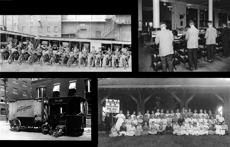
(Upper left) The latest in emergency response – the Kansas City Police Department’s new motorcycle unit, no helmets required.
(Lower left) This Waycleanse Street Sweeper was 1920s state-of-the-art city maintenance equipment, even though many of Kansas City’s streets were not yet paved by then. The Waycleanse, according to the promotional literature, was a leap in technology, designed to pick up the fine dust left behind by the conventional machines. While it may seem like a marginal difference, in fact the small fine dust was the cause of much of the problem. Litter and debris could be swept up with brooms or captured by more rudimentary mechanisms, the fine dust, continually kept adrift by traffic and winds, contained the materials that caused serious harm. It choked the engines of cars and trucks, carried waste particles from horses, and caused serious pulmonary issues. The Waycleanse machine was introduced to the market in 1920, making Kansas City one of the first cities to purchase one.
(Upper right) The information accompanying this photo gave no address, no company name, and could not identify the type of work being done. That I can do. Three of the fellows with their backs facing the camera are wearing matching printers’ coats, and all four of them are using earlier versions of the mimeograph machine – the hand-cranked, drum-based copiers many of us remember from our early school days.
(Lower right) In 1920, meat-packing was still a large part of the Kansas City economy, though nowhere near as dominant as it had been around the turn of the century. Among the leaders in the meat-packing industry that descended upon this area in the 1890s was Wilson & Company, located in Kansas City, Kansas. This picture was taken on the occasion of a company-sponsored picnic for the “Plant Girls,” the women who worked in one of the company’s processing plants. Wilson & Company operated in KCK for another 55 years, and was the last of the area’s “big four” meat-packing plants to close, having outlasted the plants of the more recognizable names of Armour, Swift and Cudahy.