
(originally published 1/23/20)
This is the first of a two-part look at the The Landing Mall, beginning with its history before the center was built. The site spent 50 years supporting a business, taking advantage of a natural setting that has long since been covered in pavement. But its fate would change with the arrival of real commercial development in the 1920’s. Next week’s post will cover its history as a development of the J.C. Nichols Company, and its struggle to find its place in the market.
The intersection of 63rd and Troost wouldn’t seem to have a history worth exploring. Today, it’s a typical urban hodgepodge of commercial buildings, each dating to somewhere in the 20th Century. There’s been no new construction there for at least the last 20 years. Some of the buildings have been vacant so long they now seem abandoned. Many are woefully underused and under maintained. The proliferation of fast food joints, check cashing storefronts and cell phone kiosks mask the fact that there are still many thriving businesses there too, like clothing stores, drug stores, restaurants, and banks.
There are intersections that look like this throughout the urban core, so if you presume the Landing site’s condition is just a part of the cycle of disinvestment and blight that often happens, you’re right, but only partly. Over the years, many forces have been at work to make 63rd & Troost what it is today, both good and not so good. And at the center of the geography, of the history, and of this story, is a shopping center that’s stood on the site for 60 years – The Landing.

In 1897, there was no 63rd Street and no Troost, at least not as we know them today. Just rough roads connecting clusters of community beyond the city limits. That’s when William Rock bought the acreage on the southeast corner of 63rd & Troost specifically for commercial use. Rock saw opportunity in the site. Its north boundary, 63rd Street, would soon connect to the property Thomas Swope had donated for Swope Park, the crown jewel of the city’s new park system. That meant traffic, and road improvements to benefit his business. But the real draw was the brook that ran along the south side of the property. Town Fork Creek flowed off the ridges to the southwest on its way to join Brush Creek and the Blue River. It wasn’t much of a creek, but it would be enough for Rock to build a small dam and capture the water in a pond before it continued on its way.

Water was essential for Rock’s business. He was a florist, and for the next 50 years, he used the property to grow plants and flowers that supplied the William L. Rock Flower Company. His 18 acres started out with 20 greenhouses, a potting house, a windmill and a water tower. The reservoir Rock created was formed by a dam that aligned with Tracy Avenue, two blocks east of Troost.

During its time, the property’s lake was a fixture in the community that filled in around it. To the neighborhood’s it was known as Rock’s Lake. In its first decade, the lake was the regular meeting place of the Kansas City Bait & Fly Casting Club. No doubt it was at some point a favorite swimming hole for local kids. That lasted almost 20 years, until 1918 when Town Fork Creek was buried as the city paved Meyer Boulevard, the latest addition to the growing parks and boulevard plan.
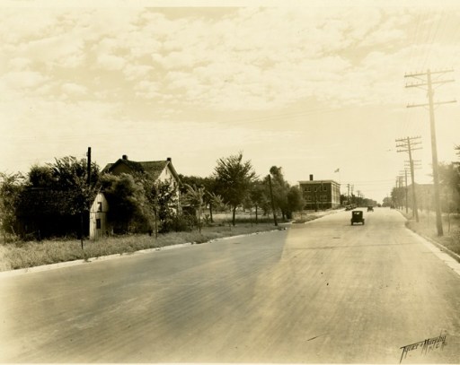
The city had been moving toward 63rd and Troost for years, and it was finally annexed by the city in 1909. The park system’s longest and most impressive boulevard, The Paseo connected to Meyer Boulevard just east of the lake. 63rd connected to Swope Park to the east. To the west it led to the Nichols Company’s Country Club District and Brookside Shops.
Of course, J.C. Nichols and the Nichols Company had a hand in all that was happening around the Rock’s Lake property. For more than a decade Nichols had been developing thousands of acres as the largest residential district in America, starting at Brush Creek and driving southward. By 1919 the Country Club District had reached just beyond 63rd Street, a key east-west axis of the company’s larger plan. Meyer Boulevard was one commercial block south of 63rd Street. A mile west of Rock’s Lake, Meyer Boulevard was a beautiful wide thoroughfare that would soon be lined by large homes and rows of large trees flanking the sidewalks. The Nichols Company owned those large home lots, as it a owned a large share of property between Meyer Boulevard and 63rd Street, with plans for single family homes and duplexes.

Sometime before 1925, the telephone company built a three story red brick building to house its Hiland exchange switching center on the northwest corner of 63rd & Troost. Two years later, the Nichols Company built a two-story yellow brick office building with retail shops on the ground level, stylistically similar to the buildings on the Country Club Plaza, which was also under construction then.
The 63rd & Troost building was Nichols staking his intent. He saw commercial potential at 63rd and Troost, and so far, his instincts had served him well. But J.C. Nichols had to wait another 20 years before he could take on a larger project – the kind of shopping center had had practically invented and for which he was certainly famous. Right before he retired in 1947, William Rock sold his property to the Nichols Company. The company cleared away the structures and started planning for its next big commercial venture.

The project had a lot going for it. By 1947, the company had serious commercial experience. Its three largest shopping areas – Brookside, the Plaza and – just now coming on line – Prairie Village were each a good but different model for a new center. The company hired, Tanner, Linscott and Associates, Nichols’ perennial choice as architects. The principle, Edward Tanner, had for years led Nichols’ architecture department. He was the architect for most of the Country Club Plaza building and of many Country Club District homes.
The project had a lot against it, too. Prairie Village was taking up the company’s immediate attention. Nichols’ health was failing, and when he died in 1950, the company still hadn’t finalized plans. The company was having trouble coming up with a scheme for which at any given moment they had the property configuration they would need. In a 1961 memo to the periodical Architectural Record, the company summed up the reason for the delay this way – “Many ideas were discussed and discarded, and as the years went by the site was held as an undeveloped island while the city grew up around and beyond it.”
Next week: The life of The Landing Mall over the last 60 years, in all its iterations of development.
(Featured Photo: A postcard view of Rock’s Lake. The view is looking east from Troost. Today’s Meyer Boulevard covers the path of the stream. Image from my personal collection.
