
(originally published 11/21/19)
For the past two weeks, we’ve been looking at the history of the Trolley Track Trail, the pedestrian and bike trail that runs from Brookside Boulevard and Volker, all the way south to Dodson at 85th & Prospect. What began as a freight line connecting Westport to south Jackson County in the late 19th century heyday of the railroad, transformed into a major feature of the south Kansas City landscape from 1900 to the 1950s, when the Country Club Line was the last to stop streetcar service. Now comes a look at what happens to a rail line that’s abandoned, and how complicated legal rights-of-way played a part in the modern physical divisions of a city. This week’s post combines excerpts from both The Brookside Story and The Waldo Story. Much of the original research came from primary research in business association archives and contemporary newspaper accounts.
As the streetcar systems in America closed down and cars became kings of the road, the demands those roads placed on cities were mounting. Combined with other problems characteristic of cities at the time – blighted properties, suburban growth, and development at break-neck speed among them – demand also rose for a method to make sense out of the apparent mayhem. Thus began the period of wide-spread urban renewal in America. Urban renewal began much earlier in metropolises of the east, most notably New York, where these already over-built cities were the first to face traffic congestion, sprawl and other urban scourges. Generalizing, the urban renewal philosophy was that the increasing physical deterioration of the homes and commercial areas of America’s inner cities represented both blight and opportunity, an opportunity to use federal dollars to eliminate blight, then build efficient highways and supporting projects to stimulate new development outside the urban core.
Such practices were already being called into question by 1960. These projects were tearing apart the poorest neighborhoods in cities, and as those neighborhoods were most often minority communities, urban renewal added to the growing awareness of racial imbalance in the country. In 1960, these marginalized groups were just beginning to find their public voice . Groups that did have voice, like the well-off residents of the Country Club District, with their neighborhoods planned for permanence by J.C. Nichols himself, would surely have felt insulated from the threat of urban renewal. Yet they were wrong.
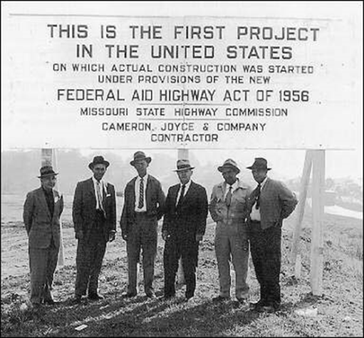
As early as 1958, there were discussions at City Hall about the possibility of a freeway through the Country Club District. Suburban development exploded after 1945, and those who lived there wanted speedy access to downtown and other points in the metro. There were interstate highway projects in the works, spurred by then President Eisenhower’s Federal Highway Act of 1956. The time seemed right to many, including the Nichols Company.
After J.C.’s death in 1950, the company had continued an impressive pace of development. While still technically connected to the original Country Club District at many points, much of its development was, in 1950s terms, a fair distance from the city center, on the southern and western edges of the metro. Now under the leadership of J.C.’s son Miller, the Nichols Company saw the proposed Country Club Freeway as a boon to that development.
In late 1959, the City began to work on condemning the streetcar right-of-way as the basis for the freeway. They wanted to take it all, from 85th and Prospect all the way north to Westport, though that wasn’t exactly how the proposed freeway would align. Advertised in modest notices in local papers, City Councilman Charles Shafer, Jr. arranged a series of meetings in impacted neighborhoods, including Waldo and the Country Club District, to explain the city’s plan, and answer questions. The whole process started out quietly and uneventfully, and for eighteen months seemed to have made only a modest impression on the community.
Those whose houses or businesses directly abutted the streetcar line did pay attention, however. When the matter finally came before the Jackson County Circuit Court in June 1961, those homeowners and other property owners were represented at the hearing by a phalanx of some fifty lawyers, requesting damages on behalf of their clients. Collectively, it was their contention that the condemnation of the rail line represented a loss in the value of their clients’ property, and they should be fairly compensated. Ultimately, this argument did not hold, but the litigation had raised the awareness of the entire community.
The City’s point man was associate City Counselor Herbert Hoffman. He had been in charge of the attempted condemnation action, and so became the City’s de facto advocate for the freeway. He was diligent, but hampered in his efforts toward progress. There were questions about the rights-of-way that would plague the easement for years to come. A poorly worded ordinance forced Hoffman back to City Council for revision, causing delays that allowed time for opposition to coalesce and gain momentum. That opposition was in full force by September of that year.
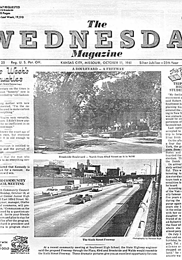
The community meetings had far outgrown the small churches where they had first been held. In the auditorium of Southwest High School, a panel came to discuss the project. For the first time, the Missouri Highway Department’s sent a representative to describe what the proposed freeway would be like. The plan called for a six-lane high speed (45 mph) non-access highway, meaning limited places for entrance and exit. It would connect with both the northern and southern tracks of the new interstate highway loop around the city. In the bounds of the Country Club District and south, most of the road surface would be below grade, twenty feet or more, with only occasional bridges to allow cars and people to cross from one side to the other. When the freeway continued north, it would come within a block of the Plaza, then rise above grade courtesy of a concrete viaduct and somehow meander northeast to connect with the interstate there. Worst of all, it would require 200 feet of right-of-way on either side of these proposed six lanes, meaning it would cut a swath through the Country Club District that could easily obliterate all structures between Oak Street on the east, and halfway between Wornall Road and Ward Parkway on the west. The Brookside Shops were in jeopardy, and along with them Brookside Boulevard, the Waldo area, and countless homes and businesses.
The description surely horrified those in attendance, and those who read of the plans in the local paper. Almost immediately, varying proposals were offered by City Hall, including one councilman’s suggestion to completely bury the freeway through the area, in other words, a tunnel. Some called for an update to the streetcar line to accommodate one of the new modes of mass transit being explored in other cities, a monorail. But even in the Country Club District and Waldo area, the freeway had its supporters who thought it represented opportunity. Freeway supporters expressed confidence and faith in the City, the State, and local interests to make sure that any plan would not disrupt the neighborhood. Opponents were more cynical. The topic spawned grass-roots community organizing, and the formation of at least a couple of community benefit associations.
For the next year, there was much discussion but no resolution. Opponents and supporters alike showed up in increasing numbers at court hearings and city council meetings. Everyone seemed to be waiting for a decision on the final plan, or the condemnation proceedings to conclude. Then, in 1963, it was time to elect a new city council and a new mayor. No candidate wanted controversy, and the freeway was certainly that. There was growing awareness that there were far more people now opposed than in favor. In July 1965, the Jackson County Circuit Court dismissed the city’s condemnation suit, forever closing its option on construction of the Country Club Freeway. In the end, the public outcries and political will of the Country Club residents didn’t stop it – it was simply a question of law. The court dismissed the case on the grounds that, as property already owned by a public entity (the Public Service Transit Company), the city couldn’t condemn the line. It would be another thirty years before the right-of-way question was resolved.
As to the freeway, earlier that spring, the Missouri State Highway Commission, no doubt frustrated by the city’s inability to move forward on the project, had already revised its recommendation. According to the Wednesday Magazine, the Commission proposed “a route farther east…for the south-town freeway, partly because it would not cost as much money as the Country Club Streetcar Route.” Forty years later, that eastern road was completed, congruent with 71 Highway, and named Bruce R. Watkins Drive. There were promises, too, that Watkins Drive would never be a highway. In 2012, Watkins Drive and the rest of Missouri 71 Highway was designated as part of Interstate 49. Just as originally planned back in the late 1950s, the city now had an interstate highway through its core that connected with the interstate loop. And just as originally feared, it forever changed the character of many eastside neighborhoods.
(Featured Photo: Photos: The Country Club Street Car Line as it was fashioned in the final years of its life.This one is approaching the Brookside Station, traveling south. Courtesy the State Historial Society of Missouri-Kansas City)
