(originally published 7/18/19)

On the home front, we’re in the midst of a taxpayer revolt in Kansas City/Jackson County over what appears to be at a minimum a poorly administered property assessment. That event took my thoughts to the story of another tax assessment that almost 80 years after its completion has turned into a story of its own.
As part of Franklin Roosevelt’s New Deal plan to revive America’s post-Depression economy, the Works Progress (later Work Projects) Administration is among the better known initiatives, largely for its infusion of art and literature-related projects initiated for the larger public good. But in its short life (1935-1942) the WPA also employed artists in service of other projects not directly related to the arts, including social services and public infrastructure. It was no doubt part of those interests that prompted the WPA to support comprehensive tax assessments for cities by employing photographers to create a photographic inventory of the city’s taxable real estate. To date, my research on this hasn’t yielded a complete list of communities that participated in the program, but New York City was one of them. And so was Kansas City.
Locally during 1940, a group of unnamed photographers methodically took pictures of every property parcel in Kansas City, and a few just outside the city limits (perhaps anticipating future expansion). Using the existing system of parcel identification, the process was relatively simple. Working in pairs, a photographer would capture the image of the parcel – some with buildings, others vacant. Included in the picture was another man holding up a board with the parcel number. The board was long enough to slide as many as nine digits into its tracks, which was changed for each property photographed.
The photos as printed were true thumbnail-sized, 1” x 1.5”. They had to be small to fit into their special folder, one folder for each block in the city. Inside, the tiny images were attached in a matrix of squares, arranged in the same position they held around their city block. There were at least 4,200 folders (called “block cards”), filled with what I personally estimate to be as many as 100,000 images.
The images did not need to be quality photography to do their job of cataloging the property. Most of them are moderate to poor quality, in fact. They were frequently framed crookedly or off center. Intense glare or deep shadows often made the image hard to make out. Overgrown vegetation was a frequent problem, usually noted in the margins of the folder. Even focus was not an issue – there was enough detail to assess the property’s value, but architectural details or signage on commercial buildings was usually blurred.
After the inventory was taken and used for assessment purposes, all the folders were presumably archived with the city, and over the years most likely continued to creep a little further back in the filing system with each passing year. What happens next is anecdotal, for I doubt anyone would have wanted to document the crime against historical research that occurred next. What does seem certain is that the city, having likely decided the information was too out of date to be relevant, disposed of the folders. The story I heard is that that were retrieved from a dumpster somewhere, and landed in the hands of the city’s former office of the Landmarks Commission (now the Historic Preservations Commission).
But whether they were in the trash or just left to deteriorate in old boxes, when the Landmarks Commission received them the damage was extensive. The photos had originally been mounted in their folders with some type of glue that had long since failed. Nearly every folder had a significant number of images missing, or almost as bad, loose and unattached in the paperwork, with no way to return them to their rightful position. Having worked through those folders for more than a decade now, I would conservatively estimate that half the total photos are now gone, though the losses are not consistent from folder to folder. Some of the folders I have worked with have lost all but a couple of pictures, but a neighborhood about which I wrote a few years ago had images of 325 of its 343 parcels.
Today, probably the most frequent use of the photos is personal, to locate a picture of a current or former home. Taken together, however, they are both a literal and a figurative snapshot of Kansas City at one rather interesting point in time. The photos are definitely of their time, reflecting the architecture, the commercial habits, the social and economic conditions and much more of a city squarely between two wars, and emerging from the dark days of the Depression.
For my books and for this page, I tend to focus on the commercial photos: they usually have more visual interest, more detail clues, and are interesting to a broader audience. I can learn the name of business and its address any number of ways, and usually something more about the story of that business, but the places where I can find a photo of that business more than fifty years old are few. The photos usually support the research, not lead it.
Yet one time, these tax assessment photos did lead the research. When I inventoried all the commercial blocks in the Brookside Shopping District, I was lucky to find most of the shops still evident among the tax assessment photos. But for the most part, I didn’t need them. Brookside was easy in that respect – the Nichols Company had a lot of photos and information, there was a professional photographer tenant in Brookside, who shot lots of commercial shots and photos for The Wednesday Magazine, and thanks to the public library I had a nearly complete collection of business names and addresses from its collection of old city telephone directories.
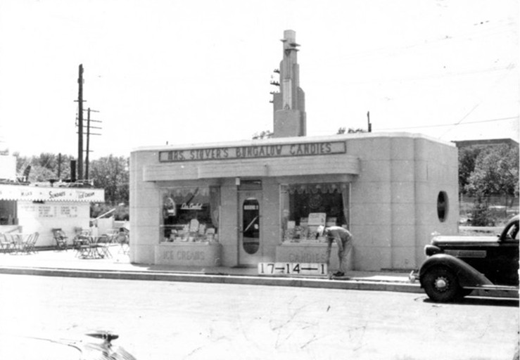
But never had I ever seen any evidence of the Country Club Dairy “Oasis” ice cream stand or Mrs. Stover’s Bungalow Candies, two free-standing one-story buildings next to each other on Brookside Plaza, where the flatiron-shaped 6314 Brookside Plaza building stands today. There were a few years from the Depression through World War II when the city directories weren’t published every year, leaving gaps in the local timeline of where people and businesses were located. 1940 was one of those years, and in this case, the 1940 tax assessment photos did much to fill in one of those gaps.
These two lovely buildings were there but a couple of years – years in which apparently nothing else had documented their presence. The two businesses connect Brookside to the larger Kansas City story in new ways. The Country Club Dairy was a leading Kansas City dairy, and given that it had a processing facility at 57th and Troost, it was certainly considered the neighborhood dairy. By its look, The Oasis, the dairy’s ice cream stand, would have been just as appropriate along a highway in a small town as it was in Brookside. It had the same low profile, the same array of walk-up windows, and the same informal picnic table seating outside.
As interesting as the Oasis is, its neighbor to the north is twice so. Mrs. Stovers’ Bungalow Candies was the original name of the Russell Stover Candies company, and in 1940, the company was just beginning to open retail shops. The “bungalow” in the corporate name described both the Stovers’ home in Denver where the candies originated, and the look of the free-standing retail shops first opened shortly after the company moved its operations to Kansas City in 1932. But not this shop. It is characteristic of what is often referred to as art moderne, a sort of last-phase art deco period. Where art deco is ornate in detail, art moderne is simpler, more streamlined, and sometimes almost industrial in character. While I haven’t yet identified a specific reason for the dramatic change in design, it is worth noting that the other buildings on Brookside Plaza were built between 1938 and 1949, and many of them originally had (and a few still retain) definite art deco features in their facades and entryways.
The addition of the Oasis and Mrs. Stovers’ Bungalow Candies to the larger Brookside story is not all that significant yet – but there’s always more research to be done and I’m still on the job. For now, the real significance lies in the photos themselves, how they came to be and almost weren’t at all if not for that WPA project. And if not for that brave soul who rescued them from that dumpster.
To view and search the database of buildings in the collection, follow this link:
Kansas City 1940 Tax Assessment Photos
(Photos: (top) Mrs. Stover’s Bungalow Candies on the north were located where the 6314 Brookside Building is today; (bottom) Directly adjacent to the north, local Country Club Dairy had an ice cream stand, known as The Oasis. Photos courtesy Missouri Valley Special Collections, Kansas City Public Library, Kansas City, Missouri.)
